9 Unbelievable Route 66 Stops Every Hiker Must Explore

From 1926 until 1985, U.S. Route 66, also known as the Mother Road and the Main Street of America, helped connect millions of Americans with the open road and beauty of their country. Even though officially the route no longer exists, many of the historic stops still remain for adventurers to explore!
There are so many places you can visit and enjoy, especially if you’re a hiker. From ancient fossilized forests to extinct volcanos, there’s something for everyone to explore.
In this list, we’ll look at 9 of the very best stops Route 66 travelers can make that will delight any hiking enthusiast. Be sure to check out our other list of Route 66 road trip stops and learn about the history of this historic highway by reading this blog!

1. Petrified Forest National Park, Holbrook, Arizona
As one of two National Park’s located along the old route, the Petrified Forest has been a popular tourist destination since the highway’s inception and is the only National Park to still contain a section of Route 66. Containing colorful, fossilized wood that dates back to about 225 million years ago, it’s no wonder the park still attracts curious and inspired visitors who want to explore this unique landscape.
For hikers, the park contains many easy-to-moderate trails that not only traverse through the petrified forest but the many archeological sites dating back to over 12,000 years ago. Discover the landscape of the Painted Desert with trails like the 1-mile Painted Desert Rim Trail, the 1-mile Blue Mesa trail, the 1.2-mile Tawa Trail, and 0.4-mile Giant Logs trail.
For a longer hike, combining the Long Logs and Agate House Trails will take you on a 2.6-mile journey through parks largest concentration of petrified wood as well as the ruins of a 700 hundred year old pueblo house. Many of the trails are paved but some sections are gravel with a few steep inclines to traverse.
After your hike, be sure to also check out the Painted Desert Inn, a pueblo revival style complex built in 1937 that now serves as a museum, bookstore, and in the summers, an ice cream parlor.

2. Grand Canyon National Park, Arizona
While you’re exploring Arizona, it’s worth taking the slight detour from Route 66 to visit the always awe-inspiring Grand Canyon. Despite not having being on the original route, the Grand Canyon has been a popular detour with tourists since the highways inception.
For a hiker, it’s desert paradise with plenty of trails that explore this over 200-mile long natural beauty. The South Rim of the canyon is the most accessible from Route 66 but those who want to extend their detour can drive further on to the North Rim as well.
Day hikes are the best option for those who want to keep their trip a little shorter and get back on the road. Just don’t confuse short hikes for easy hikes as there are no easy trails in or out of the canyon.
If you’re looking to tackle a longer, multi-day hike, the 21-mile Rim-to-Rim Trail is an extremely challenging (and bucket-list worthy) hike that will test your limits while exploring the majestic beauty of the canyon. It requires a stop in either the Bright Angel Campground or, if you make advanced reservations, at stay at the Phantom Ranch lodge.
For longer hikes, just remember that a permit will be required.

3. Amboy Crater, Amboy, California
A 6,000 year old extinct volcano formed of ash and cinder, the Amboy Crater is one of the most unique natural landmarks to visit on your Route 66 road trip. Designated a National Natural Landmark in 1973, it’s an example of a very symmetrical volcano cinder cone and is recognized for its visual and geological significances.
There’s a 3-mile round trip trail that will take hikers up and into the 250 foot tall crater as well as around the rim. It’s a steep, rocky trail showing a landscape that has been transformed by ancient volcanic ash when the volcano last erupted 10,000 years ago.
If you really want to experience Amboy Crater at its most beautiful state, visiting during late January through March is when the desert landscape is blanketed in golden wildflowers. There’s also a shaded crater viewing platform and picnic tables for visitors to use.
Just be sure to bring plenty of water as temperatures can get very hot, especially during the summer months. It’s best to avoid visiting during these days as the heat can be very real and very dangerous.

4. Mojave Desert National Preserve, Barstow, California
While you’re visiting the nearby Amboy Crater, be sure to also stop by the Mojave Desert National Preserve and explore this 1.6 million acre park filled with mountains, canyons, and iconic Joshua tree forests. Explore this desert wilderness and hike through both the established trails and backcountry routes.
Although this preserve was officially established almost a decade after the decommissioning of Route 66, it can still serve as a great stop for those traveling the routes historic remains. Mojave is perfect for any hiker with trails that suite all skill-levels.
Popular trails include the easy Hole-in-the-Wall Nature Trail, the moderate Kelso Dunes, and the difficult Piute Creek which requires a high clearance, four-wheel drive vehicle to access the trail. There’s a wide variety of options ranging from beginner to advance so all visitors can enjoy and explore the preserve.
Remember that if you’re attempting to hike any of these trails, especially the backcountry routes, be prepared with enough water and provisions to combat the heat.

5. Petroglyph National Monument, Albuquerque, New Mexico
Traverse one of the largest petroglyph sites in North American featuring symbols and carvings created 400 to 700 years ago by Native Americans and Spanish settlers. These images carved into the volcanic rock preserve the thoughts and expressions of early descendants and settlers of North America.
You can check out several hiking trails that traverse past these ancient petroglyphs as well as the sand dunes and scenic views of the Rio Grande Valley and the Sandia Mountains. The Boca Negra, Rinconada, and Piedras Marcadas Canyon trails each contain hundreds of petroglyphs to view.
You can also hike the many trails in the Volcanos Day Use Area that range from easy to moderately strenuous. Check out sweeping views of Albuquerque and the Rio Grande Valley as well as the remnants of a historic corral.

6. Pacific Crest Trail, San Bernardino, California
Spanning over 2,600 miles from California to British Columbia, the Pacific Crest Trail (PTC) is often a bucket-list hike for many adventurous outdoor enthusiasts. For travelers of historic Route 66, it can be accessed along an old section of the highway just north of San Bernardino called Wagon Trail Road.
For anyone traveling the entire trail, they’ll pass through 25 national forests and 7 national parks along the way. At just the Route 66 entrance point, the PCT passes through the surrounding San Bernardino National Forest which offers lots of hiking spots and places to view and climb the nearby mountains.
This is the only place where Route 66 travelers can access the PCT from the Mother Road which makes for a unique blend of automotive and natural history.
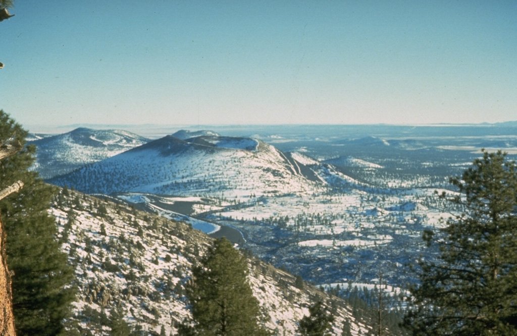
7. San Francisco Volcanic Field, Flagstaff, Arizona
An area covering 1,800 square miles at the southern boundary of the Colorado Plateau, the San Francisco Volcanic Field contains 600 volcanoes that range from 1 million years old to less than 1,000. It is just north of Flagstaff with hills and mountains that extend all the way to the Grand Canyon and is just outside the world’s largest ponderosa pine forest.
Visitors can hike the many cinder cones and lava domes that range from 300-600 feet high. The surrounding mountains can also be hiked with the two most popular being Humphreys Peak and Mount Eden.
Humphreys Peak is the only alpine summit in Arizona and stands at over 12,000 feet tall. Despite this, it’s a relatively easy hike and gets a little busy on the weekends.
While the area is quiet now, the volcano field is still active and there will be more eruptions in the future. The good news is the last eruption occurred over 900 years ago and there are no signs of activity for the foreseeable future.

8. Palo Duro Canyon State Park, Canyon, Texas
Known affectionally as the “Grand Canyon of Texas”, Palo Duro Canyon’s specular landscape was carved by millions of years of water erosion and stretches roughly 120 miles while descending over 800 feet. It’s also only 25 miles from downtown Amarillo and is the second largest canyon in America.
Palo Duro has over 30 miles of trails for Route 66 hikers to explore right in the heart of the Texas Panhandle. There are hikes for every skill-level to enjoy that provide stunning views of desert scenery and the canyons four geological layers.
Check out the historic Cowboy Dugout on the Paseo Del Rio Trail that shows how the cowboys lived in the 1880s, or, cross 4 historic bridges on the CCC Trail. Also be sure to watch out for the Texas horned lizards that inhabit the canyon.
After your hike, you have to option to stay at one the many campsites in the park. If you’re looking to camp in style however, try a night of “glamping" in a fully furnished cabin with air conditioning, kitchen amenities, an outdoor fire pit, and a covered porch with a hammock.

9. El Malpais National Monument, Grants, New Mexico
Spanish for ‘the badlands’, El Malpais is a beautiful volcanic landscape located just outside the Route 66 town of Grant. Known as the land of frozen fires, visitors can explore the many lava tubes scattered throughout the area as well as the grasslands, sandstone bluffs, and forests.
There are many hikes to choose from ranging from strenuous trails that traverse over jagged lava flows to moderate loops through the surrounding forests. You can also hike on a portion of the Continental Divide Trail that runs through the park.
Explore the many underground lava tube caves as you navigate the rugged, uneven terrain. The El Calderon Area trail climbs to the top of the El Calderon cinder cone as wells as through juniper and ponderosa pine forests.
With all the tough terrain, be sure to wear a pear of sturdy hiking boots to prevent any jagged lava rocks from puncturing your feet.

Conclusion
With these 9 hikes, Route 66 travelers will have no shortage of places to stretch out those legs and explore the historic highway a little more in-depth.